Customize Consent Preferences

We use cookies to help you navigate efficiently and perform certain functions. You will find detailed information about all cookies under each consent category below.

The cookies that are categorized as "Necessary" are stored on your browser as they are essential for enabling the basic functionalities of the site.... 

Always Active

Necessary cookies are required to enable the basic features of this site, such as providing secure log-in or adjusting your consent preferences. These cookies do not store any personally identifiable data.

Functional cookies help perform certain functionalities like sharing the content of the website on social media platforms, collecting feedback, and other third-party features.

Analytical cookies are used to understand how visitors interact with the website. These cookies help provide information on metrics such as the number of visitors, bounce rate, traffic source, etc.

Performance cookies are used to understand and analyze the key performance indexes of the website which helps in delivering a better user experience for the visitors.

Advertisement cookies are used to provide visitors with customized advertisements based on the pages you visited previously and to analyze the effectiveness of the ad campaigns.

Cutting-Edge Surveying, Positioning & Sensing Solutions for Hydrographic & Oceanographic Applications
HydroBoat 1500 Heavy-payload USV for underwater topographic survey
HydroBoat 1500

Heavy-payload USV for underwater topographic survey

Visit Website Contact
Saved
Save
HydroBoat 1500

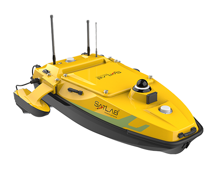
The HydroBoat 1500 USV is designed to carry out efficient underwater topographical surveying of lakes, rivers, reservoirs and other bodies of water. With a payload capacity of 60 kg and driven by four powerful thrusters, it is ideal for equipping with the SatLab HydroBeam M4 portable multibeam echosounder, as well as a variety of other payloads such as side scan sonars and ADCPs.

The robust vessel is IP67-rated for maximum durability, and includes a millimeter-wave radar and 360° omnidirectional camera for accurate obstacle detection and safe navigation. It is equipped with a high-precision GNSS receiver and IMU as well as a dual RF and 4G cellular communications system, allowing it to be operated at effectively unlimited range.

Specifications:

Dimensions (L x W x H) Monohull: 1528 x 694 x 494 mm
Trimaran: 1528 x 1034 x 494 mm
Weight 40 kg (no battery)
Max Payload 60 kg
Max Speed 5.7 m/s
Endurance 4.5 hrs @ 1.5 m/s with two batteries
(vessel can take up to six batteries)
GNSS Performance RTK positioning accuracy: H ±8mm + 1 ppm RMS, V ±15mm + 1 ppm RMS
Heading accuracy: 0.2° @1m baseline
INS Accuracy: 2.1°/h, <1m/20s
Saved!

Visit My Account to view and manage your saved content.

Just click the icon at the top-right of the screen.